May 2019
The Club reminds Members with vessels trading in the southern Red Sea and Arabian Sea that the geographical limits of the High Risk Area (HRA) have changed as of 1 May 2019.
While the industry group of shipping and oil industry organisations responsible for setting the HRA (BIMCO, International Chamber of Shipping (ICS), INTERCARGO, INTERTANKO and the Oil Companies International Marine Forum (OCIMF)) continue to emphasise that a serious threat remains, the ongoing containment of pirate attacks in the Indian Ocean means that a reduction in the area’s geographic boundaries is appropriate. Notwithstanding the HRA reduction, the group continues to stress that correct reporting, vigilance and adherence to the 5th edition of the Best Management Practices To Deter Piracy And Enhance Maritime Security in the Red Sea, Gulf Of Aden, Indian Ocean and Arabian Sea (BMP5) remains crucial.
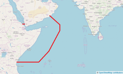
From 1 May 2019 the new coordinates of the HRA are:
Southern Red Sea: a northern limit across the Red Sea at the latitude of 15° 00’ North
Indian Ocean: a line linking:
- The territorial waters off the coast of east Africa at the latitude of 5° 00’ South to 050° 00’East
- 0° 00’ North, 55° 00’ East
- 10° 00’ North, 60° 00’ East
- 14° 00’ North, 60° 00’ East
- Then a bearing 310° to the territorial waters of the Arabian Peninsula
The UKHO Maritime Security Chart, Q6099, will be updated by a Notice to Mariners and a new version has been produced to reflect the changes above (Edition No. 7, dated 2 May 2019).
The advice can be downloaded via the Maritime Global Security website.